Walking in the Outer Hebrides
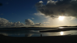 Getting to the Outer Hebrides involves a long sea crossing or a flight, so there’s already a sense of the exotic before you even arrive. The long chain of islands, stretching from Lewis in the north to Vatersay and Barra in the south, has plenty of surprises in store; curving beaches of golden sand, rugged mountains shrouded in mist, coastal grassland that is host to hundreds of species, ancient sites from prehistoric times onwards and, of course, the Atlantic ocean in all its moods. Unsurprisingly, none of the islands is highly populated and much of the landscape can genuinely be described as wilderness, so if you want an experience of remoteness, this is the place to come.
In spite of this, the Outer Hebrides is not at all difficult to get to. The ferry company, Caledonian MacBrayne (‘CalMac’) operates a network of crossings from the mainland and island to island. Thanks to government support the pricing is based on an equivalent cost to travelling the same distance by car (taking all the costs of car travel into account). CalMac also have some excellent deals on ‘island hopping’ routes, called their ‘Hopscotch’ itineraries. This allows you to start in one part of the chain, hop to one or more islands and return via a different route. At the end of summer 2013, for instance, we drove to Oban on the west coast of Scotland and took the ferry to Lochboisdale on South Uist. We drove up through the Uists and Benbecula and made the short crossing to Harris. We left the islands from Stornoway on Lewis for Ullapool, which is a four or five hour drive from Edinburgh or Glasgow. The total cost for ferries was around £130 for the vehicle, plus £40 per person. The dog travelled free.
 Each of the islands has its own distinct character, in large shaped by the natural landscape. The beaches to the south have a fine silvery sand; they become golden as you venture further north. Much of inland Harris is a rocky and barren wilderness, often referred to as a ‘moonscape’, with some reason. Over wide areas there are more lochs and lochans than dry land. The fertile coastal plain found on most of the islands is known as ‘machair’. As well as being the location of a long crofting tradition, the machair grasses provide cover for a wide variety of ground nesting birds, mammals and insects. In spring and summer it’s the venue for a spectacular display of wild flowers.
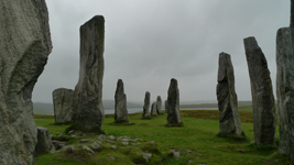 If it’s history you are after you’ll find it aplenty. There are impressive standing stones from the prehistoric era, including the famous Callanish stones and the outlying sites that surround it. Callanish has a posh new visitor centre. Bronze and Iron Age settlements have been excavated from the shifting sand dunes, with an intriguing reconstruction of an Iron Age house at Bostadh on Great Bernera. Here we chatted to the incredibly knowledgeable custodian, who kept a peat fire going throughout the day and talked about her experiences with making pottery, textiles and adapting the architecture of the building itself – true experimental archaeology. The Blackhouse Museum on Lewis (www.gearrannan.com) provided an insight into life in the squat stone walled houses of an almost untouched hamlet, inhabited right up to 1970s.
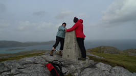 In the very remote parts of the islands, in particular on the hills and mountains, there are few well-trodden tracks, but here and there you’ll find a stalking track or even an old coffin road providing access into the wilderness. There are many more paths around the coastline, not all of which are marked on the Ordnance Survey map. The coast alternates between rocky foreshore and sandy beach, with paths running through the sand dunes and machair and up onto spectacular headlands. As with the rest of Scotland there is assumed ‘right to roam’, so it’s a question of finding your way and taking care not to disrupt livestock or wildlife.
The islands are not without their economic problems. There’s a wide discrepancy between the wealth displayed by those visiting or indeed living here for the shooting and fishing and those scraping a living from traditional crofting, fishing or the short tourism season. Stornoway on Lewis is the largest town on the islands, but its centre has a somewhat rundown feel, with empty shops and a few tired looking public houses – though it’s not without a certain charm. Ferry ports like Tarbet on Harris have only one of everything, if you are lucky – one bank, one grocery shop, one fish and chip shop, one restaurant, one petrol station. As you travel around, especially if you are camping, you need to plan your purchasing of stocks carefully, so you don’t land in the middle of nowhere with no dinner!
What you will find almost everywhere are tea shops and cafes, often attached to a craft shop, small museum or community centre, and within them a friendly welcome and a proper homemade tea or meal. There are not many pubs, particularly on the fundamentalist Protestant islands of Harris, Lewis and North Uist, but there are hotels and inns with restaurants if you want a meal out. We had an excellent meal at the Polochar Inn (www.polocharinn.com) on the southern tip of South Uist.
Many residents offer B&B accommodation if you don’t want to pay out for a hotel room. The campsites on the islands, though few and far between, are beginning to set high standards, with new toilet blocks and occasionally luxuries like Wifi. They tend to be open from around April to September. The Kilbride Campsite on South Uist (www.kilbridecampsite.co.uk) and Balranald Campsite on North Uist (www.balranaldhebrideanholidays.com), set on an RSPB reserve, were both superb. Somewhat more basic, but in a truly fantastic location, was the Cnip Grazing campsite on Uig, Isle of Lewis (look on www.coolcamping.co.uk for this and others on the northern islands). The Cnip campsite is owned by the community, and indeed community run enterprises seem to be a welcome and growing development on the islands. There’s an excellent community shop near to Cnip, a lifeline as the nearest town of Stornoway is some 40 miles away.
One thing that was almost universally available was mobile phone reception. In most places it was possible to get a decent mobile data connection too. This won’t matter to many, especially if you are heading to the Outer Hebrides purposefully to get away from modern technology, but we have the Walkingworld website to look after! Even without the work aspect, it was useful to access the web for information on places to visit and to book accommodation.
David Stewart
Official tourist information: www.visitouterhebrides.co.uk
Caledonian MacBrayne: www.calmac.co.uk